Hi, I'm experiencing a problem, in implementing polygons in maps, I'm following the following steps: I create the geometry column using the following command:
ALTER TABLE "TABLE" ADD GEOMETRY COLUMN SDO_GEOMETRY
immediately after inserting the geojson data:
INSERT INTO "TABLE" (GEOMETRY) VALUES (SDO_UTIL. FROM_GEOJSON ('CORDERED DATA', srid => NULL))
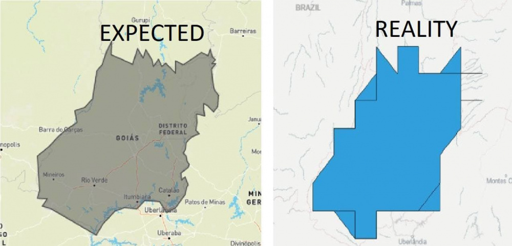
GEOJSON data IS:
{ "type": "Polygon", "coordinates": [ [ [-47, -17], [-47, -16], [-47, -16], [-47, -16], [-47, -16], [-46, -16], [-46, -15], [-46, -15], [-46, -15], [-46, -15], [-46, -15], [-46, -15], [-46, -14], [-46, -14], [-46, -14], [-46, -15], [-45, -14], [-45, -14], [-46, -14], [-46, -13], [-46, -13], [-46, -13], [-46, -13], [-46, -13], [-46, -13], [-46, -12], [-46, -12], [-46, -12], [-47, -13], [-47, -13], [-47, -13], [-47, -13], [-47, -13], [-48, -13], [-48, -13], [-48, -13], [-48, -13], [-48, -13], [-48, -12], [-48, -12], [-49, -12], [-49, -13], [-49, -13], [-50, -12], [-50, -12], [-50, -12], [-50, -12], [-50, -13], [-50, -13], [-50, -13], [-50, -14], [-50, -14], [-51, -14], [-51, -14], [-51, -15], [-51, -15], [-51, -15], [-52, -15], [-52, -16], [-52, -16], [-52, -16], [-52, -16], [-52, -16], [-53, -16], [-53, -17], [-53, -17], [-53, -18], [-53, -18], [-52, -18], [-53, -18], [-52, -18], [-52, -18], [-52, -18], [-51, -19], [-51, -19], [-50, -19], [-50, -19], [-50, -18], [-50, -18], [-50, -18], [-49, -18], [-49, -18], [-48, -18], [-47, -18], [-47, -18], [-47, -18], [-47, -17], [-47, -17], [-47, -17], [-47, -17] ] ] }
I'm leaving an image with the expectation of displaying the codes mentioned above, and how the result is really coming out.