Hi Team,
I have Latitude , Longitude of a country and I want to convert that into SDO_GEMOETRY column which basically stores the shape of the country in the column.
When I do
update country set geometry = MDSYS.SDO_GEOMETRY(2001, 8307, MDSYS.SDO_POINT_TYPE (60, 100 ,NULL),NULL,NULL) where NAME='RUSSIAN FEDERATION';
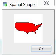
And try to see "Display Geometry Shape"
I get only 2D Polygon shapes suported.
But when I check for the other countries which was already inserted in the db, I see "Display Geometry Shape", it shows me the shape of country.
If i see the code behind it, it is using SDO_ELEM_INFO_ARRAY. However in my update statement I am using SDO_POINT_TYPE.
MDSYS.SDO_GEOMETRY(2003,8307,NULL,MDSYS.SDO_ELEM_INFO_ARRAY(1,1003,1),MDSYS.SDO_ORDINATE_ARRAY(-114.50095,32.39957,-111.0757,31.33201,-110.94267,31.33262,-110.94237,31.33262,-108.20844,31.33339,-108.20854,31.78378,-106.52863,31.78377,-106.48896,31.74808,-
Can someone help me out so that I can see the shape for the record which I inserted ?
Any help would be appreciated.
Regards,
Akash